I'll now quote some of the remarks which more accurately reflect an evident sense of extreme wonder and surprise of the astronauts over a place far more fantastic than it was shown or reported to be in the photos at the top of this page. This is done with help from the Apollo Lunar Surface Journal , and found in the following sections
Traverse from Camelot to Geology Station 2 , and Geology Station 2 at the base of the South Massif .
142:35:44 Schmitt: Man, this has been a trip.
142:35:46 Cernan: Man, I tell you. You know, we're really up on top of this thing. Whoo!
[Schmitt - "Nansen isn't actually an impact crater but, rather, is an anomalously-deep, elongated depression that is part of the trough. It isn't filled as much as other parts of the trough. From the gravity measurements we know that, just before the mare lavas filled the valley, the difference in elevation from the valley floor to the tops of the South Massif may have been something of the order of four to five kilometers. That is, there appears to be now about two kilometers of mare basalt filling the valley. Originally the elevation difference was even more than four or five kilometers because there is strong evidence that the mountains have been subsiding over time, enough so that you never accumulate a talus at the base. The evidence of this is the trough that runs along the base of the massif. If you imagine a steeply dipping-fault between the South Massif and the original valley and the mountain subsiding relative to the valley, then the fault tends to open and either the talus tends to accumulate or you get a trough or both. Most people think that, once those mountains formed, they stayed relatively quiet; but the trough implies that there's been activity essentially up to the present. Otherwise, you would have filled up those troughs. Essentially, the gap is opening up as fast - or faster - than talus is accumulating, from a volume point of view. The average exposure age of the talus material is very low and does not correspond to the age of the mountain. The mountain formed 3.9 billion years ago and the exposure age of the soils in the trough is a few hundred thousand years."]
{Now, wait a second. This is described as a half filled impact crater! This is not what the surface photos show of it.. and Jack Schmitt's later description above is more or less sounding like a blanketing explanation, It doesn't fit the area as shown by the photos of it I've displayed at page top. Jack says "The Gap is opening up as fast.. or FASTER than Talus is accumulating." Could that be because of a hollow under it? And the age difference? KL}
142:39:01 Schmitt: That is a high mountain!
142:39:03 Cernan: Jimmeny Christmas! Listen, if the Earth goes behind it, we're changing Station 2. (Laughter)
142:39:11 Schmitt: Gonna be nip and tuck, pardon the expression.
{nip and tuck? KL}
142:41:12 Schmitt: See, there's Nansen off to my right now.
142:41:14 Cernan: Yeah, I just want to make sure that I'm not driving down a hole here...which I am, but...I don't want to drive down (into) Nansen.
142:41:23 Schmitt: No, you won't. The end of Nansen is over there near those blocks. Right over there. (Pause)
142:41:39 Schmitt: Look at those blocks! Unfortunately, the good boulder tracks are over into Nansen
142:44:27 Schmitt: Look at Nansen!
142:44:31 Schmitt: My goodness gracious.
142:48:40 Cernan: Man, we are down in a dep(ression)...Look at where we came down, Jack. And that was just one of the hills. Got to go back up and then down some.
{Now does the image supposed to be of Nansen have what it takes to have caused a reaction like that? Doubtful. Nansen as shown by the images as represented seems hardly evocative of these reactions. Here we have a seasoned geologist exclaiming "Look at those BLOCKS!!" but we get a picture of a fairly barren block barren trench KL}
142:51:13 Schmitt: (To himself) Okay. (Talking louder to Bob) Okay, Houston, the number of blocks plotted on the map are not nearly enough. In the greater than 1-meter range, there are many hundred blocks on the massif flank of Nansen (that is, on the south side of Nansen) and up around Station 2, where we are. There are only one or two blocks on the light mantle side of Nansen. It looks as if the material in the bottom of Nansen is overriding the light mantle materials of the north wall (of Nansen). That's just an impression. They (the South Massif talus)'re slightly lighter albedo than the north wall of Nansen.
142:52:06 Parker: Okay. Copy that, Jack. Looks fantastic up there.
142:55:18 Cernan: One comment. When you look down into the bottom of Nansen, it looks - like, I guess, would sound obvious - that some of the debris that has rolled off of the South Massif covers up the original material there that covers the north wall of Nansen. There is a distinct difference. You've got that very wrinkled texture in the north slopes of Nansen, and you've got the South Massif debris in the south slopes of Nansen. And the debris, of course, overlays the north slope. And all the rock fragments, all the boulders that have come down, are all on the south side of the slope of Nansen.
{It is obvious from the orbital maps that this area is quite blocky, and it is evident in the transcript that Schmitt says it is even blockier than the maps show, yet here are these surface images showing an area that can't be described as particularly blocky at all, and what happened to all the sharp lineations on South Massif? Perhaps they also see that they are not going to be able to get into the massif for the debris covering the opening? What we can glean from this last statement is that there isn't a way in, but what's left is pretty remarkable KL}
143:02:39 Cernan: There may be an overhang. And look at that, that rock is fragmented; let's see, it's southeast/northwest. There's a split.
(Are they simply describing rocks? KL)
143:05:11 Cernan: And I didn't park that Rover in a very good spot for them to watch what's going on, I guess; but that was the heading.
143:05:16 Schmitt: Oh, shoot. They're missing all of it.
143:05:18 Cernan: We didn't work in the right spot; that's all.
143:05:21 Parker: Every now and then we get a peek at you guys. But only every now and then.
143:05:27 Schmitt: Sorry, Bob.
143:05:31 Cernan: Oh, wait a minute.
143:05:36 Schmitt: You know, that's the way it happens.
{So we see here that the TV camera has been picking up none of this excursion. "You know, that's the way it happens." Could this have been on purpose?
It would seem that something would have been said about it by Mission Control. Instead, nothing. What we have is a blank spot in the events. That's the way it happens?? The TV camera does catch a decent look down into Nansen however, and shows much the same view as the image at page top, you can see it here, http://www.hq.nasa.gov/office/pao/History/alsj/a17/a17v.1431452.ram KL}
143:22:08 Cernan: Well, I have some good pictures of Nansen, anyway, and...(Long Pause) You know, I look out there, I'm not sure I really believe it all.
{Where are these pictures? Not in the catalogs, I can say that with fair certainty. I'm having a hard time believing it too. What a very telling statement from Gene. Is this why none look directly into the Massif side of Nansen. KL}
1143:41:23 Parker: Beautiful station, guys; just simply beautiful. Almost deserves a Falcon code.
143:41:31 Cernan: Man, I'll tell you. (Laughing) Falcon 109. I couldn't help that, Bob; it's just too beautiful. (Pause)
{Beautiful station for us all had we gotten to see it. Leaving the area, the guys get a good look at the Scarp, read this carefully, it is very revealing. A falcon code means indescribably "F'in" incredible. KL}
143:50:49 Schmitt: Keep turning around over there, and I'll get that Scarp. That's beautiful.
143:50:54 Cernan: Isn't that something? Man, you talk about a mysterious looking place. (Pause)
143:51:03 Schmitt: They can cut some frames - some parts of those pictures out - and make a nice photograph. (Laughing) (With the) TV camera, (and) maps (in the way). (Pause)
[The pan turned out to be relatively uninteresting because of the Sun glare. Pictures taken during the next minute or two are AS17-138- 21093 (**), 21094 (**), 21095 (**).]
{Well how about that? An extremely mysterious looking place they are compelled to photograph, half retracted talk of cutting parts of the images out covering them with the TV camera and maps "in the way" and the resultant images are deemed "uninteresting because of Sun glare! I take it the guys were not allowed to photograph certain geologically unexplainable oddities and didn't really appreciate it, then it seems when they did anyway the images didn't "turn out". KL}
Now, when I read through the full transcripts of this time during the traverse, I'm struck by this question; what were they actually seeing and describing in these instances that would cause a seasoned field geologist and an experienced lunar astronaut to react in this way?
Not what the first two images above that are supposedly Nansen show us, that's for sure.
This part of the mission and all its anomalism seems to have escaped the detection of many that have studied the images and transcripts, and cause extremely polarizing views among those that have simply by the very mention of the subject matter. The question is why? I cannot help but to draw inferential parallels between this and A.C. Clarke's 2001, A Space Odyssey. It seems a patently obvious possibility. A suspected artifact from a prior intelligence seen, a rush to get there, and the extreme need to keep it a secret at the time, perhaps all time.
Remember Dr. Heywood Floyd's speech to the lunar base personnel in 2001? At all costs this was to be kept silent...
Why did what may be the greatest discovery ever in the history of mankind get the obscuration treatment? If what I surmise from this data is even partially true it is cause to rejoice.
I think this document says it all, from The Brookings Institution, supplied courtesy of
The Enterprise Mission.
Let me sum up what we've gone over so far and roughly outline what this mission may have actually been about.
This is something I reveal only because it is evidently obvious that the data available and missing does back up these conclusions.
It is our right to know. I feel that if we were robbed of a great legacy by the hiding of these almost fantastically unbelievable findings, it is time to make it right.
An anomalous and highly geometric area is spotted and photographed by Apollo 15. This area contains a huge, almost perfectly centered hexagonal artifact surrounded by an enormous square plain bordered by linear massifs full of yet more anomalies. After further study of the images and science data, it was discovered that this six sided structural artifact is located directly at 19' 5", 30'33"- very near "19.47", a favorite number shown numerous times to be involved in the mission planning regularly done by NASA. Found also in the images was what could very well be an opening leading into said artifact.
These facts likely made getting to this area with the last Apollo mission imperative, even though landing in the middle of the area chosen was very dangerous. Once the landing was achieved and site equipment deployed the astronauts took the rover for a long drive right over to this opening. They passing up many other areas which would have been of extreme geologic interest and risked their very lives by endeavoring to navigate through the many obstacles along the way. If not for a single gentle slope up the Scarp appropriately called Hole-in-the-Wall they might not have made it there at all.
Once arrived, they did not park the rover so that the TV camera was pointing towards them and recording their actions. Few pictures were taken while they explored this hole, and the ones that were are apparently a ruse. It is probable they were looking for but did not find a way into the massif. All the while along the way Gene and Jack were exclaiming loudly about how unbelievable the place was, and in the same breath trying to explain it geologically. I gather this would have been a most difficult air to maintain, and it shows on review of both the transcripts and audio. As if our guys didn't have enough to shoulder by experiencing all this first hand, they couldn't even say it exactly like they were seeing it, though they left hints.
The images of these features obtained while on location don't really show what is so plainly obvious on most of the orbital images or what was so exciting to Gene and Jack; namely a large hole in the side of an ancient structural artifact. It is reasonably suspected and quite executable that the few photos taken of Nansen were captured from vantage points that simply could not see down into it, in order to keep the hidden mission further under wraps.
Explosives were also deployed at set locations all along the traverse. After further explorations towards North Massif and the areas west and north of the landing site, (where they found among other things orange soil) they left the Moon.
Upon leaving the surface and docking with the Command Module, the ascent stage of the Lunar Module was crashed directly into South massif; and where else but at a number that has been noticeably repeated throughout the entire mission, 19.5. The seismic charges they planted across the valley floor at strategic locations were also detonated. The aim of all this explosive destruction upon this fantastic area was to detect density variations in the local area subsurface, and within South Massif itself.
An experiment, called "Chapel Bell" was performed during this time; an experiment with results that are still classified over thirty years later and that was also performed on Apollo 14, 15, and 16. It is widely speculated to have something to do with a curious property of the Moon: to "ring like a bell" for long periods after a seismic event. I tend to think it may have instead had something to do with the detection of subterranean hollows under and around this site. We won't know until declassification, which is long overdue.
This photo shows both the planned and actual impact point of the ascent stage.

"The LM impacted with a speed of about 1.5 km/s and with a mass of 2400 kilograms. The impact energy was therefore, 2.7e16 ergs. From a paper by V.R. Overbeck, we estimate that the total displaced mass was about 6.7e8 grams. Then, if the mean density of the target material was 2.0 g/cc and the crater was conical in shape with a depth one-fourth its diameter, the crater diameter was about 17 meters.)"
A major portion of the seismic experiment package (SEP) is said to have failed. What good data there was collected from this experiment shows that the charges and impact did indeed cause the Moon to "ring like a bell" for some time afterwards.
For those interested enough to download and read the 87 mb pdf document containing the preliminary science results of this mission, it is located here,
Apollo 17 Preliminary Science Report
USGS wrote a professional paper on the area,
The Geologic Investigation of the Taurus-Littrow Valley: Apollo 17 Landing Site
Part IV. Spectral Vision
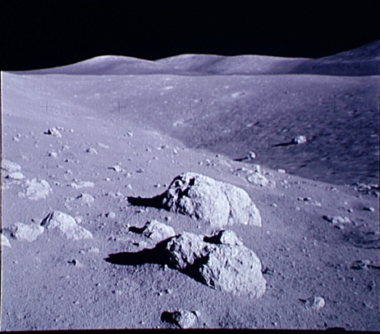 Here is a look back into Nansen from near the vantage point shown by white dot (# 2) in the far bottom left corner in the traverse map shown on the previous page. I suspect that this photo is from behind the overhanging ledge top. Nansen appears far too shallow, and does not reconcile with the orbital photos of it nor with the exclamatory transcripted descriptions. For one, there is no shaded overhang on the massif-side, which is shown on every single orbital photo, regardless of lighting angle, for two it is not shown to be very anomalously deep, as described by Jack. we may be peering from above and behind the overhang onto the other side of Nansen, and the dichotomy in the middle may be the overhang's top edge. What is further down in the "Anomalously deep" area, which cannot be seen?

