Similarity of Three Possibly Artificial
Structures on the Moon & Mars
By Keith Laney
Many noteworthy anomalies can be found in the huge planetary
imaging data bases we've collected over the decades. As the body of satellite
data expands and the Apollo & other lunar photographic resources receive
the proper attention they deserve, so also does the body of evidence pointing
to possible advanced ancient human or extraterrestrial activities. That
the ancients did have access to advanced technologies and science is evidenced
by the giant structures and records they left all over our world. Many
of these ancient records, such as the Sumerian and Indian epics Enuma
Elish and Mahabharata, speak of space travels,
aircraft, mighty weapons, terrible wars (even on the moon), and "gods".
Some of the ancient megalithic structures survive to this day, and defy
our modern ability to recreate them. The Great Pyramids at Giza, Sacsayhuaman,
and the terrace of Baalbek are outstandingly good examples of this. In
consideration of these evidences, it would seem logically sound thinking
to look for similar structures on our planetary neighbors if we wish to
find confirmation of the ancient testimonies.

It is my conclusion from research that the moon and our
other neighboring planetary bodies harbor visual evidence of this type
of activity, and this evidence is just as or perhaps more impressive than
has been found on Earth. This is not only plausible, but also long documented
and reported by many of the individual researchers that have honestly and
open mindedly delved into our archived planetary imaging collections. Besides
the numerous lunar archives scattered about in the Regional Planetary Image
Facilities system, there are literally hundred thousands of digitized planetary
images stored in the Planetary Data System, USGS, and Malin Space Science
Systems. Kennedy & Johnson Space Center's online Apollo images are
also readily accessible, albeit incomplete, along with many other various
NASA digital data resources. I am one of the many that have plunged headlong
into all the above, and as a finder of many things anomalous in these planetary
image collections, I can personally and positively attest to this fact;
all you have to do is look, learn to recognize what you see, and carefully
sift the signals from the noise.
The fairly ludicrous first individual attempts at publicly
showing possible artificiality on other planetary bodies were from the
likes of those such as Fred Steckling (Alien Bases on the Moon),
and George Leonard (Somebody Else is on Our Moon) They were
met by the lunar and scientific community with harsh refutation, and for self
obvious reasons. This derision
left the subject a virtual comedy and source of ridicule by the
more scientifically minded. Upon closer examination, most of their reportedly
anomalistic lunar oddities were for the most part far too over scale, unresolved,
and non-referentially described to be warranted as convincing evidence for artificiality. Although one must semi-admire them for trying to do something
with what limited resources were available at the time, and for drawing
the interest of many others more competent to handle the data, it is likely
they hurt this cause more than helped.
Due to the meticulously referenced, more scientifically based
researches made by several more capable others over the years, a large body of convincing evidence in favor of
an artificiality explanation for many conventionally unexplainable planetary
features has been compiled. As an associate of this more serious type of study, I have taken the task of insuring
that contributions to the best of these photographic evidences are preserved
for posterity. This study has not been and must not be allowed to sink
into obscurity. As one of the few individual "civilians" with visual access
to a copy of the complete lunar imaging archives, and having spent many
hours studying the photos in it, I both discovered and concur through
examination with many prediscovered anomalous findings.
I am proud to be able to further contribute to this research.
.
It is also my conclusion that despite the objective opinions
of many planetary geologists, which group includes lunar selenologists
and Martian areologists, some of the anomalous objects as seen in the planetary
images seem indicative of intelligent design and construction. The origin
of these objects by an improbable yet possible ancient space faring race
lost from our histories (or perhaps an extraterrestrial presence) must
be considered as a valid and relevant hypothesis in instances where the
planetary geology fails or is incomplete. This is especially possible given
the body of evidences available here on our own planet that point to the
same conclusions. We are left to ponder what degree of activity and influences
these ancient astronauts or extraterrestrial entities may have had rather
than if they were present at all.
In the following imaging study, I’m presenting a mere "scratch
on the surface" of the total data acquired that backs this theory. We will
be going over a set of three fairly distinguishable similar anomalous structures
found in photographs from three different locations and three different
missions, two on the Moon and one on Mars.
All images used below are scanned reproductions of NASA original
photographs and digital originals specially gathered and selected for their
high quality from the actual photographic archives of NSSDC (National Space
and Science Data Center), Johnson & Kennedy Space Centers, and Malin
Space Science Systems.
AS8-13-2224 and 2225. A view of Goclenius
 The first manned
circumlunar mission of Apollo 8 captured thousands of high resolution
photographs of the lunar surface. As with all the Apollo mission images these
are referenced by mission, film magazine, and frame. For example AS8-13-2224 = AS8 (mission) 13 (magazine 13) 2224 (frame
number).
The first manned
circumlunar mission of Apollo 8 captured thousands of high resolution
photographs of the lunar surface. As with all the Apollo mission images these
are referenced by mission, film magazine, and frame. For example AS8-13-2224 = AS8 (mission) 13 (magazine 13) 2224 (frame
number).
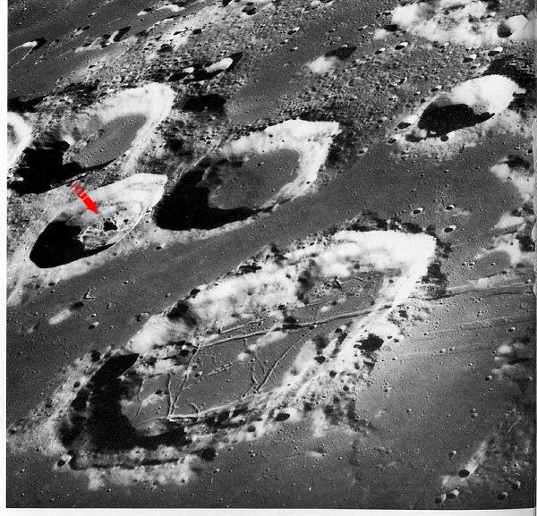
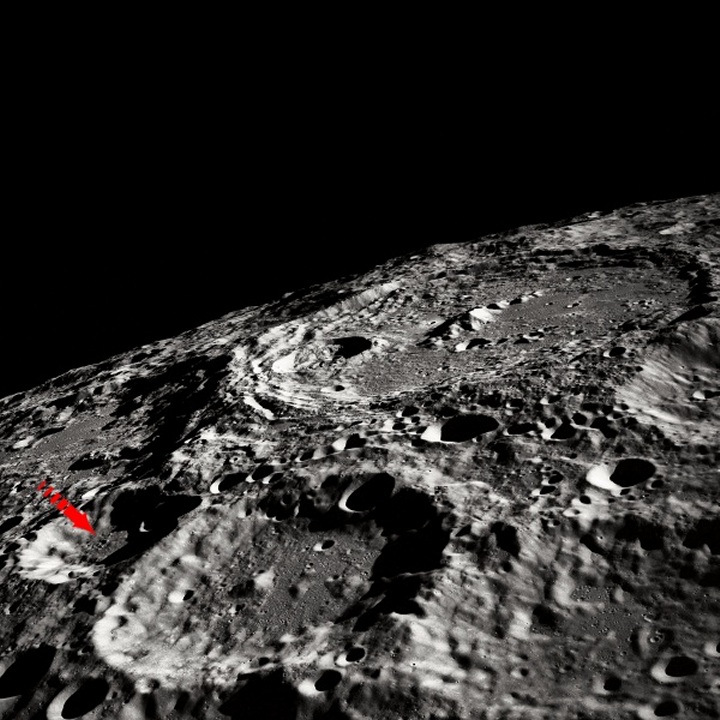
Two very interesting and revealing AS8 images are the following
oblique photos of crater Goclenius and its immediate vicinity. The image
center is near 45 degrees east longitude and 10 degrees south latitude
in the Sea of Fertility. On both photos the largest crater seen in the
foreground is Goclenius, which is approximately 70km in diameter. There
are three other craters above Goclenius, from upper left and under to right
they are Columbo A, Magelhaens A, and Magelhaens. The first example of
the structure appears in the near center of Magelhaens A, the smaller (approx.
32 km. diameter) rough floored crater under Columbo A. The location coordinates
for Magelhaens A are 12.6 south lat, 45.0 east long. Bear in mind here
that the scale is very large, and the structure is huge by Earth standards.
The lighting in both of these images is coming from the lower left. According
to image orientation this would be from the east, as evidenced by the shadows.
Evidenced also by the shadows the object itself casts; it is a standing
structure, extending upwards. The structure is arrowed.
AS8-13-2224
 Now we will take a look at its higher quality sister image, taken moments later
and from slightly farther to the right. I have the same object arrowed, and it
is fairly visible in both of the size reduced full image examples displayed
here. The two photos are very much the same in scale. They were taken by the
same camera, with the only differences being the slight angle change between the
two frames because of the distance the spacecraft had traveled westward. Note
there is only a small position change difference between the two.
Now we will take a look at its higher quality sister image, taken moments later
and from slightly farther to the right. I have the same object arrowed, and it
is fairly visible in both of the size reduced full image examples displayed
here. The two photos are very much the same in scale. They were taken by the
same camera, with the only differences being the slight angle change between the
two frames because of the distance the spacecraft had traveled westward. Note
there is only a small position change difference between the two.
AS8-13-2225
To view AS8-13-2225 as officially digitally represented go to
http://lunar.arc.nasa.gov/archives/images/USA/Apollo_08/Moon/medres/10074967.jpg
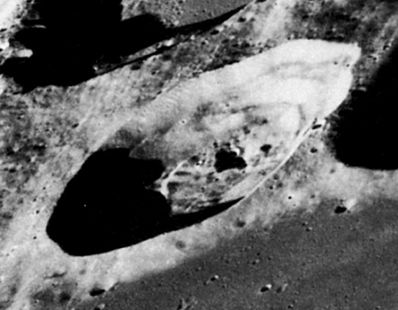 It must be realized that these two images as displayed are smaller
than actual size of 8x10, and far smaller than they can be enlarged accurately.
You may also notice the other curiosities in the area. That there are other
items here deserving a closer look is a truism, but we will be concentrating
on a specific structural object to be our focus.
It must be realized that these two images as displayed are smaller
than actual size of 8x10, and far smaller than they can be enlarged accurately.
You may also notice the other curiosities in the area. That there are other
items here deserving a closer look is a truism, but we will be concentrating
on a specific structural object to be our focus.
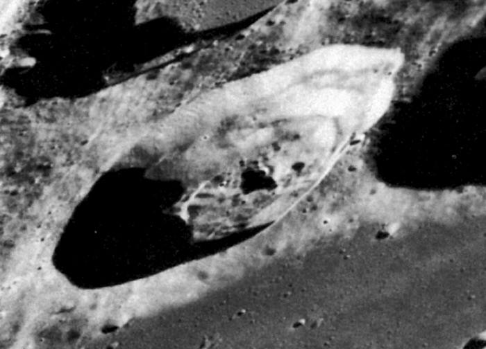
AS8-13-2225 is evidently the better of these two images. For
this reason I chose it for doing the detailed sectional enlargements shown
below. This process is necessary in order to see the smaller and more delicately
subtle details that may escape notice due to the overall scale of the object
and its surroundings. The bicubic and bilinear resizing method was employed
in enlarging these high resolution digital photo examples. This method
has long ago proven its accurate effectiveness in increasing image size
while remaining true to actual photographic content.
Here is a carefully enlarged sectional taken from AS8-13-2225 showing
the entirety of Magelhaens A. The object in question is the rectangular
tiered/stepped structure in the center sitting diagonally opposed to our
point of view.
Using the officially stated size of the crater for reference,
I estimate the general dimensions of the structure to be nearly four by
three km. square at base, and better than one and a half km.tall. Notice
the double line leading towards the left and right from the central area
the object sits on, which is indicative of walls or perhaps a "causeway".
The central complex is surrounded by visibly peculiar rectilinearities
on all sides, indicative of additional outlying structure. These are attributes
common to most archaeological ruins here on Earth. There is a bit of damage
from a small impact to the structure's far left corner, as evidenced by
the little crater seen on its edge. On the right side and partially obscured
by the shadow cast by the central structure ruin are two larger overlapping
impacts. This would probably account for the further erosional destruction
of the general area and collapse of the central structure. Now I'll take
us in a little closer. On both this and the above image I've adjusted the
contrasting a bit. This adjustment allows only the strongest structural
edges to remain evident.
This is a cut from a 2200dpi scan of a low gen print I own
For the next image we'll review, I've used the digitized version
of a negative-generated and sectionally enlarged analog photograph. Colleague Steve Troy obtained
a negative copy from NSSDC,
and had it developed by a professional photo lab. The high quality and
definition achieved from photographic enlargement using actual analog negatives
affords us a detailed view of these peculiar features unobtainable by any
other means providing the film is fresh. Sadly this negative was of fairly high
generation so much detail will naturally be lost. In this version, we are brought in close enough to see the
individual structural components of this complex and the destruction that
has resulted in its present collapsed appearance. As in aerial archaeology,
the main outlines of a ruined structure are clearly visible when viewed
from further away, then fade somewhat as we move in closer. This property
has resulted in the discovery of numerous ancient ruins by aerial means
that would have otherwise been unrecognizable from the ground. That is
what we see happening here, the seemingly sharp structural edges as defined
above now show themselves to be dissolved a bit, as we would well expect
from a ruined structure of this size.

Now that we are down in the crater with the wreckage, the complexity
of the former structure starts to become clear. I've taken what I see as
the main outlines of the larger structures and traced their edges. There
are several arcologies I've arrowed along the roughly rectangular outer
perimeter, also outlined. Notice that at the lower part of the structure's
bottom side are what may be arched openings. There is what could
be a called "quonset hut" shape arrowed on the far left edge. In the middle
of the large center structure is what could surely be termed a collapse,
notice the depressed "window pane" appearance. All in all, I've seen actual
verified ruins on Earth from the air that looked less artificial.

In order to check the validity of my claim that this is no common
impact cratering structure, I reference a definitive source
on lunar cratering morphology: The Lunar and Planetary Institute's
Lunar
Impact Crater Geology and Structure publication found here;
<http://www.lpi.usra.edu/expmoon/science/craterstructure.html
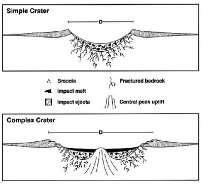 "Craters on the Moon with diameters larger than about 15 kilometers
have more complex forms, including shallow, relatively flat floors, central
uplifts, and slump blocks and terraces on the inner wall of the crater
rim. In craters on the Moon with diameters between about 20 and 175 kilometers,
the central uplift is typically a single peak or small group of peaks."
"Craters on the Moon with diameters larger than about 15 kilometers
have more complex forms, including shallow, relatively flat floors, central
uplifts, and slump blocks and terraces on the inner wall of the crater
rim. In craters on the Moon with diameters between about 20 and 175 kilometers,
the central uplift is typically a single peak or small group of peaks."
Here is a visual example they give of both simple and complex
craters. Magelhaens A is an example of Nectarian crater. The others
around it on this image are Nectarian as well, but it only has a raised,
tiered, mare material free inner structure. "Mare Fecunditatis occupies
a pre-Nectarian impact basin (center: 0.7° S, 56.30° E; 690 km
diameter) filled by ejecta from younger basins (Nectaris (oldest), Crisium,
and Imbrium (youngest)). On this brecciated, highlands- composition, basement
were deposited multiple basalt flows ranging from ~3.5-3.75 b.y. to 3.4
b.y .The lavas of Mare Fecunditatis are extensive, but thin."
It is obvious from these images that all the craters in the vicinity
both large and small are simple, having flat bottoms and floors that are
flooded with thin mare material (Which is typical of Fecunditatis) except
Magelhaens A, which has a magnificently tiered, right angled, stepped central
structure and no evident mare flooding.
This
is a true oddity, for in it lies a deep central depression with a huge
structure fitting the description of a ruin looming over it, in fact, right
on top of it! By what is known of superposition, this feature does not appear to fit the
accepted model.
The stepped structure sitting among the highly geometric shapes
spread over this crater bottom does not appear to fit into the pattern
of observable impact structures locally or into the models as established
in the LPI graphics above. Its sectional appearance and size in relation
to the total crater diameter of 32km. does not readily make it a very good
candidate for being a central crater peak, or multiple peaks. The shadow
it casts and its visible attributes reveal a two, possibly three tier right
angled construction not caused by but destroyed from the local impacts
around it.
This structure in itself is a fine stand alone candidate for
possible artificiality, but there is more. There are others objects much
like it in different locations. These will either strengthen the conclusion
that this type of structure is artificial in nature or bolster the fact
that there is an uncommonly unique type of morphology going on in these examples
not readily explained by currently accepted models.
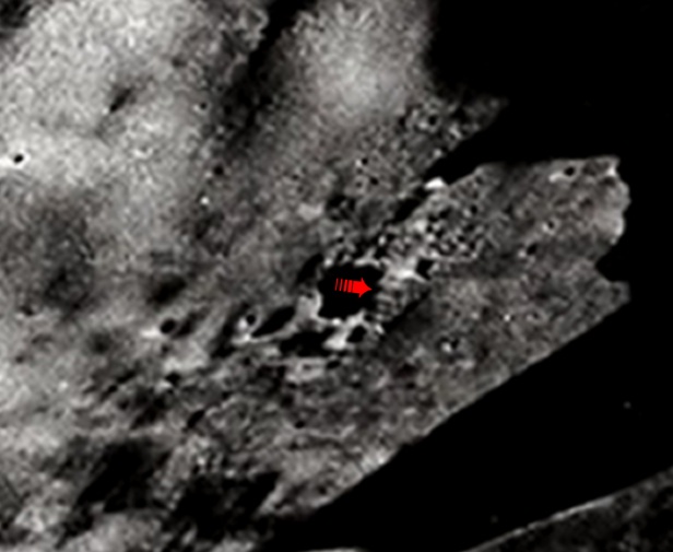
AS10-32-4823 IAU crater 302
The next structure with similarities to the one as shown above
was captured by Apollo 10 on the second ever manned circumlunar mission.
It can be found on NASA image AS10-32-4823. This photo is among the best
I've seen from the Apollo 10 collection, and can be readily found in the
Greatest
Images In NASA as GPN2000-001487. If you would like to see it in
full size you can find it here:
<http://grin.hq.nasa.gov/ABSTRACTS/GPN-2000-001487.html
This oblique view of IAU Crater 302 (Keeler) was taken by the
AS10 astronauts in May 1969. Its central coordinates are 162 deg. 2 min.
east and 10 deg 1 min. south. There are four dominant features in the area.
The largest one is Keeler crater, which dominates the image along the upper
right horizon. Directly to the left of it is Heaviside (another quite anomalous
area).The larger crater covering most of the bottom left portion of the
image is Stratton. Between Stratton and Heaviside is the smaller crater
Stratton K, located at 7.4S,165.8E. This crater contains the structure
and will be the focus here. Again, the scale on this photo is huge. Stratton
K, arrowed below, is 41km in diameter.
AS10-32-4823
Unlike the two previous photos, AS8-13-2224 and 25, the lighting
on AS10-32-4823 is from the upper right as the picture is oriented, or
west. This creates nearly an opposite shadowing effect from what is seen
in the previous images. Like the others, this one contains many other oddities
we will forego. Although represented much smaller than actual size here,
the photograph is still noticeably strong on clarity. This property makes
it very suitable for both enlargement and surface analysis. Apollo oblique
frames offer us a great wealth of information about lunar surface detail.
The elevations and angles of three dimensional structures combined with
the effects of depth and lighting combine to give us a more accurate perception
of the shapes and properties of intricate surface features. These features
might otherwise be unidentified given higher viewing angle and lighting.
The arrow in the full image above points into Stratton K and at the structural
object, which is near the crater's center..
A closer look at the object as seen from a sectional enlargement
reveals that what we are seeing in the center is in fact very similar to the tiered angular structure shown on the first set
of images.

This object is not as highly elevated, or on a "platform" like
the one shown on AS8-13-2225, and of course this one sits in a crater which
is larger by 9 km. Nevertheless, the similarity of these features is remarkable.
Most strikingly similar about it are the tiered layers. The object's shadow
is cast over a depression and reveals its general shape on the surface
behind it, much as the object in Magelhaens A's shadow does the same over
the depression in front of it. As with the first structural anomaly,
I applied bicubic and bilinear sectional enlargement to bring us in a bit
closer for a more detailed look.
I estimate it also to be nearly four by three km. square at the
base and close to two km. tall. Damage has been acquired over time on this
one also, evident by the couple small impacts around it. The similarities
of this structure to the one in Magelhaens A, which include overall estimated
size as well as the geometric items lying nearby, strike me as being more
than merely fascinating. I see an emerging pattern. I cannot help but to
be observantly speculative and state that these do seem to resemble some
degree stepped pyramid based complexes with associated surface structures,
very much like many of the ancient monumental structures here on Earth.
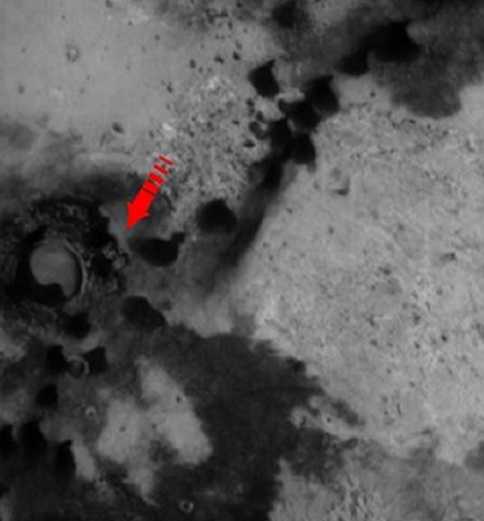
AB110004 and Mars
As if two of these objects on the Moon weren't enough!
For our next view of another very similar object we’ll have to
switch planets, missions, and image sources to Mars, the Mars Global Surveyor
and MSSS. Shortly after going into service while still undergoing aero
braking, MGS returned image AB110004. This image and it's associated ancillary
data is readily viewable via Malin Space Science Systems' archival website
at the following.
http://www.msss.com/moc_gallery/ab1_m04/images/AB110004.html
The object lies near -47.10 lat 341.20 long on the right
side of what may be described as a crater, but in appearance is more alike
to a sludge or settlement pool. The whole image is entirely too large to
display here, so I’ve cropped it down to a large part of its lower section
for convenience. The arrow points to the object.
AB110004
MGS' Mars Orbital Camera (MOC) produces excellent digital images
at a nice resolution for the most part, and since it measures the images
in meters per pixel we can obtain a nice estimate of actual object size.
In this case, a little over 9 meters per pixel. The object appears to be
both rectangular and tiered. A size estimate of it reveals a length width
and height of approx. 246x183x118 meters at base. Around it are some very
intricate shapes and surfaces, also indicative of outlying structures within
a complex.. That this is in fact an impact is not at all necessarily evident,
as is the case of several other "impact features" on Mars not covered here.
We will assume it is.
Unlike the similar objects shown above on the Apollo images,
this one is on the crater's side. Both structure and crater are much smaller.
Also unlike the others, Mars has an atmosphere and is possibly a living world. The
planetary geology is very different from that of the moon, but not so much
the impact structures. Here we again find the same type of object. Its
shadows reveals its shape just like the others. The dynamics of position
and size may a bit different, the appearance is not. The lighting is coming
from the upper right, which would be east.

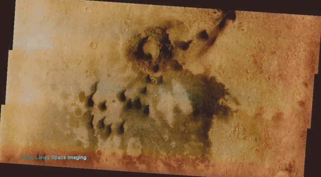
Here is this area in lower resolution but
wonderful color via Odyssey's vis camera

Now let’s look at all of the above structures together
on one image
as a collage to compare them, and for easy correlation.
Three similar right angled, tiered, possibly artificial
structure found on two different worlds during three different missions, all not fitting the standard and accepted models as being impact
originated.

The shapes and lines within these craters as displayed in this
study stand out as being very well placed, exhibiting complex geometric
organization. All of them contain attributes far more reminiscent of being
archaeological in nature than geological. Quite frankly, it resembles many
ancient ruins on Earth as seen from the air.

Aerial archaeology has been the single most important development
in that branch of science since its inception. It has so far proven invaluable
as a principal means of locating and identifying suspected ancient ruins
of this type on Earth. There is absolutely no reason other than negligence
for the same principles not being applied to suspected artificial ruins
elsewhere. The Moon's surface has been pored over by geologists, but not
by archaeologists. This is a result of either gross oversight, or overt
avoidance and neglect of scientific responsibility.
The possibility of finding remnants from other civilizations
during our ever developing space endeavors has been discussed for decades,
and by think tanks no less illustrious than The
Brookings Institution. Their conclusions on this matter were
that it would be detrimental to our civilization if knowledge of such findings
were announced. This is more than likely the reason why the Moon has escaped
the attention of archaeologists and the research application of archaeological
principles and practices. The fact that this study must be purely photogrammetric
is of little consequence, because photographic analysis is the primary focus of
aerial archaeology. The only thing lacking towards applying this to our
planetary neighbors is physical verification, or ground truth
That impact origination is the explanation for all the above
areas which contain these structures is possible, theoretically plausible,
and nearly unquestionable except for these tiered objects which do not
follow impact uplift peaking patterns as referenced by accepted models.
The one on Mars figures prominently in this respect, because it is inexplicable
for a central crater uplift or peak to be formed on the crater's side,
almost outside of the crater completely, and it is far higher than the crater
rim.
 In summation, the similarity of these objects both to each other
and to ancient ruins and step pyramids (with their associated outlying
structures) found here on our world calls for a much closer look into the
likelihood that we are actually seeing structural evidence of ancient human
or extraterrestrial habitation. It may be that there is a not-so-common
natural phenomenon that churned out some fairly equal sized right angled
tiered structures surrounded by rectilinear geometric objects in the middles
and sides of some impact craters. I opt from evidences personally witnessed
to agree with the former.
In summation, the similarity of these objects both to each other
and to ancient ruins and step pyramids (with their associated outlying
structures) found here on our world calls for a much closer look into the
likelihood that we are actually seeing structural evidence of ancient human
or extraterrestrial habitation. It may be that there is a not-so-common
natural phenomenon that churned out some fairly equal sized right angled
tiered structures surrounded by rectilinear geometric objects in the middles
and sides of some impact craters. I opt from evidences personally witnessed
to agree with the former.
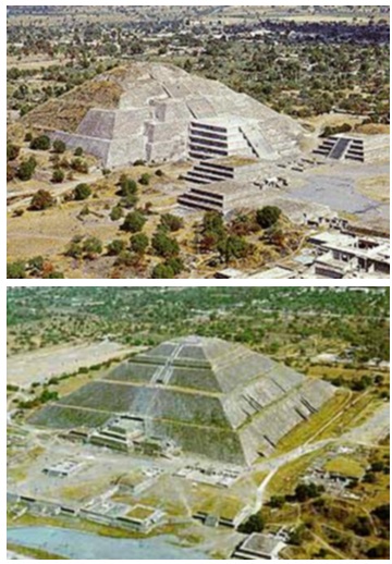
Perhaps objects of the type found on Earth, such as these seen
below, might offer a better explanation as to the origin of the structures
I've shown above from the Moon and Mars? I see them as being highly similar.
Huge tiered right angled ruined structures with outlying infrastructure,
built by man or his predecessors (be they an ancient advanced civilization
or extraterrestrially originated), still standing defiantly against the
damages wrought by time. Although their origins are thought known, they
stand as the silent sentinels of what we actually don't know at all, both
here and on our neighbors.
Is it a crater or an archaeological site?
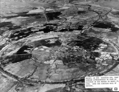
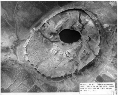
With another hundred or so more miles of distance and the decay of several
thousand more years they might be indistinguishable.
Images and text copyright property of Keith Laney 5/21/2002.
Unauthorized use prohibited!
Image sources credited to NASA, USGS, Malin Space Science Systems,
Steve Troy, The Oriental Institute at the University of Chicago, and an
unidentified individual responsible for taking the wonderful pyramid images
above.
